The last sub-study of my thesis project, dealing with canopy cover estimation using airborne laser scanning, was finally published in RSE. This one was by far the most laborious of the five papers that belong to my dissertation. The first four were nice and compact studies concerned with clearly defined problems. But the last one became a mammoth with four variables of interest, seven different data sets, and several techniques that were tested. This is a story of how it evolved.
From the very beginning it was obvious that laser scanning had potential to provide very detailed canopy cover measurements. Laser-based cover indices had been shown to have a high correlation with cover estimates derived from hemispherical images, but how would it perform when compared with Cajanus tube measurements? Both methods provide a large number of binary canopy/open samples from the area of interest, with the difference that laser pulses are not usually exactly vertical.
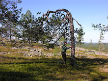
The field work for this study started already in the spring of 2006 at the Koli national park, which had been scanned previous summer. Looking back now, this one was one of the best field campaigns I’ve had – sunny days, no mosquitoes, beautiful lake views from the hills and good company made the time there enjoyable, despite the rather primitive accommodation...
When the Koli campaign was finished, it actually took me more than two years until I finally got the first results out! There were just so many other research papers to be written. In addition, 30 plots from Koli were not quite enough. Summer 2008 saw the continuation measurements take place at the Hyytiälä research station. I came to contact with Dr. Ilkka Korpela, who already had several laser data sets with basic field measurements from Hyytiälä. I measured canopy cover at 22 plots, and an additional LAI data set by hemispherical photography. Plenty of work, but I was quite happy with the resultant data set, even though it was not without problems…
The next fall was mostly spent analyzing the various field data. Spring 2009 I finally started the actual work with laser data. I had written one LiDAR paper before, but then the laser calculations were made by the others, and I focused on modeling and writing. An unwritten rule in the Joensuu forest inventory research group is that every PhD student writes his/her own software for analyzing LiDAR point data, just to learn how it is done. Of course the results would come more quickly if we just used one of the existing implementations, but sometimes the process is more important than the result.
The simultaneous programming/writing part took more than a year. The contents of the study evolved a lot during the process. The original idea of publishing also the aerial image results in the same paper was abandoned early on. Still, there were seven separate laser data sets and several methods of deriving the canopy cover from them (even after the LiDAR intensity variables were omitted). That would have been enough for a research paper, but I decided to also publish the results from hemispherical images in the same study. In my view some of the existing research papers had confusion with the field data: different field measurements were used but the results were still considered comparable. Often it seemed that the quality of field data was much inferior to the quality of the laser data. Now I had a chance to show that different field measurements are best modeled using different LiDAR metrics and models, so I decided to put it all into a single paper to give a clear view of my opinion.
The manuscript became quite long, which could be the reason why two out of five reviewers gave up reviewing it. The completed reviews were mostly positive. Of course there were plenty of corrections and we had to decrease the length of the paper considerably (which of course made it better). But most importantly, I got my point through, and the final version has practically everything that I (currently) have to say about this issue. The paper came out in January, so the process took nearly five years! Hopefully it will find its audience.
From the very beginning it was obvious that laser scanning had potential to provide very detailed canopy cover measurements. Laser-based cover indices had been shown to have a high correlation with cover estimates derived from hemispherical images, but how would it perform when compared with Cajanus tube measurements? Both methods provide a large number of binary canopy/open samples from the area of interest, with the difference that laser pulses are not usually exactly vertical.
The field work for this study started already in the spring of 2006 at the Koli national park, which had been scanned previous summer. Looking back now, this one was one of the best field campaigns I’ve had – sunny days, no mosquitoes, beautiful lake views from the hills and good company made the time there enjoyable, despite the rather primitive accommodation...
When the Koli campaign was finished, it actually took me more than two years until I finally got the first results out! There were just so many other research papers to be written. In addition, 30 plots from Koli were not quite enough. Summer 2008 saw the continuation measurements take place at the Hyytiälä research station. I came to contact with Dr. Ilkka Korpela, who already had several laser data sets with basic field measurements from Hyytiälä. I measured canopy cover at 22 plots, and an additional LAI data set by hemispherical photography. Plenty of work, but I was quite happy with the resultant data set, even though it was not without problems…
The next fall was mostly spent analyzing the various field data. Spring 2009 I finally started the actual work with laser data. I had written one LiDAR paper before, but then the laser calculations were made by the others, and I focused on modeling and writing. An unwritten rule in the Joensuu forest inventory research group is that every PhD student writes his/her own software for analyzing LiDAR point data, just to learn how it is done. Of course the results would come more quickly if we just used one of the existing implementations, but sometimes the process is more important than the result.
The simultaneous programming/writing part took more than a year. The contents of the study evolved a lot during the process. The original idea of publishing also the aerial image results in the same paper was abandoned early on. Still, there were seven separate laser data sets and several methods of deriving the canopy cover from them (even after the LiDAR intensity variables were omitted). That would have been enough for a research paper, but I decided to also publish the results from hemispherical images in the same study. In my view some of the existing research papers had confusion with the field data: different field measurements were used but the results were still considered comparable. Often it seemed that the quality of field data was much inferior to the quality of the laser data. Now I had a chance to show that different field measurements are best modeled using different LiDAR metrics and models, so I decided to put it all into a single paper to give a clear view of my opinion.
The manuscript became quite long, which could be the reason why two out of five reviewers gave up reviewing it. The completed reviews were mostly positive. Of course there were plenty of corrections and we had to decrease the length of the paper considerably (which of course made it better). But most importantly, I got my point through, and the final version has practically everything that I (currently) have to say about this issue. The paper came out in January, so the process took nearly five years! Hopefully it will find its audience.